
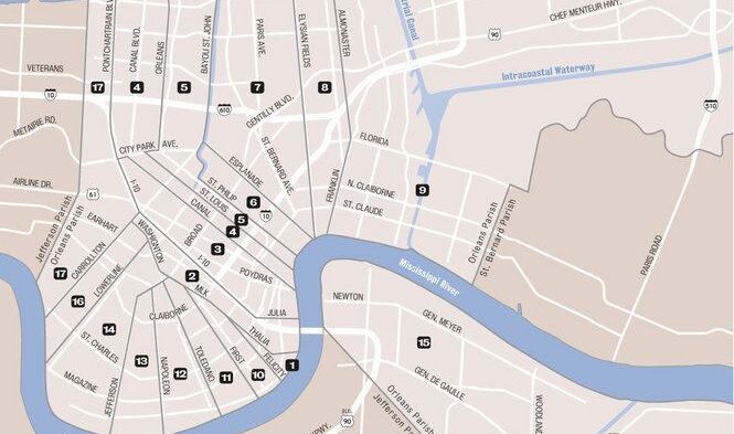
When people hear “New Orleans,” many immediately think of the city’s iconic wards — cultural hotbeds, identity markers, and rallying cries from bounce music to political campaigns. But how did we end up with 17 wards? And why do they matter so much?
At Newtral Groundz, we dove into the archives to unpack the political, cultural, and racial dynamics that shaped the ward system — a system that hasn’t changed in nearly 150 years but still defines the city.
1805: The Birth of the Wards
New Orleans’ ward system started in 1805 when the city government divided the area into seven wards. This wasn’t about neighborhoods or culture — it was about political control, tax collection, and keeping the city governable as it grew.
1836: The Great Split
By the 1830s, tensions between the French Creole, Anglo-American, and immigrant communities boiled over. So much so, the city split into three separate municipalities, each with its own council, police, and ward structure.
Each section had its own set of wards, leading to confusion and conflict. These divisions were racially, linguistically, and politically charged — a sign that power and geography were always connected in New Orleans.
1847–1880: The Expansion Era
As New Orleans absorbed surrounding cities like Lafayette (now the Garden District), Jefferson City, Algiers, and Carrollton, new wards were carved out — not based on population, but on annexation.
Key milestones:
- 1852: Consolidation created a unified city government with 11 wards.
- 1870–1874: The annexation of Jefferson City, Algiers, and Carrollton added Wards 12 through 17.
- 1880: A final boundary adjustment locked in the 17-ward structure we still use today.
Why Haven’t the Lines Changed Since 1880?
After 1880, the city essentially froze the ward map. Despite massive population shifts, natural disasters like Katrina, and post–Jim Crow demographic changes, the political geography has stayed exactly the same.
Why? Because ward lines are power. Changing them could redistribute political influence, alter voting districts, and shift the cultural centers of the city — things few politicians want to touch.
More Than Lines: A Cultural Blueprint
Today, wards are more than administrative boundaries — they’re identities. From the Third Ward chants of Magnolia to the pride of the Seventeenth, these lines define the sound, slang, and soul of the city.
But knowing their history reveals something deeper: the ward map isn’t just a product of urban planning — it’s a record of struggle, growth, and resistance.
TLDR: Timeline of Ward Changes
| Year | Event |
|---|---|
| 1805 | City incorporated with 7 wards |
| 1812 | 8th Ward added after statehood |
| 1836 | City split into 3 municipalities |
| 1847 | Wards expanded to 18 |
| 1852 | Unified city creates 11 wards |
| 1870 | Jefferson City & Algiers added (Wards 12–15) |
| 1874 | Carrollton added (Wards 16–17) |
| 1878 | Minor boundary shifts |
| 1880 | Final ward boundaries established |
Final Word
The next time someone reps their ward, remember — they’re repping more than geography. They’re repping history, identity, and survival.